NeoGeoInfo has done this projectfor Uttar Pradesh Public work department (UPPWD) under project entitled “Populating GIS Based Digital Map including cost of Digital Maps and Road side features Extractions, Road attributes attachment for eighteen districts in the state of Uttar Pradesh AND Development of Road & Bridge information system (RIS) application based on Geographical Information System (GIS)”.
Type of service
Populating GIS Based Digital Map including cost of Digital Maps and Road side features Extractions, Road attributes attachment for eighteen (18) districts in the state of Uttar Pradesh AND Development of Road & Bridge information system (RIS) application based on Geographical Information System (GIS).
Scope of Work
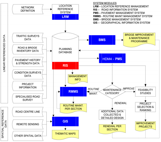
Creation of ‘GIS’ based ‘Central Repository’ for the road data of 19 districts, which can be used by UPPWD for decision making
To assist in e-Governance initiatives,
Creation of a Platform to graphically review, view, and analyze the road data with the help of latest ‘GIS’ based Digital Map’.
Location reference of the ‘UPPWD Road Network’ and integrated road data.
Framework for collection of road data and updating ‘GIS’ based ‘Digital Map’ database on a sustainable basis,
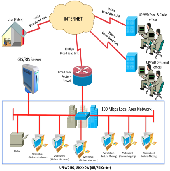
Setting up of ‘GIS’ facility including required hardware, software and other related logistics at ‘UPPWD’s head quarter and zonal offices.
Project Background
A reliable network of transportation through highways, roads and bridges, provides building blocks to carry out social and economic reforms towards making a progressive and economically strong and financially independent state.
As such, ‘Public works Department’ in the state of Uttar Pradesh (UPPWD) was established in 1854 and entrusted with the responsibilities to provide public services for development and maintenance of roads, buildings, bridges and dams across the state.
Today ‘Public Works Department’ only focuses on development and maintenance of roads and bridges in and across State of Uttar Pradesh. While the emphasis has had always been on road construction and its maintenance, the state government has also realized the importance of adoption of ‘Geographical Information System’ (GIS), in alignment with National ‘E-Governance Program’ (NeGP), to digitized statewide roads and bridges network towards providing a modern, efficient, effective and a transparent ‘Road & Bridge Information Management System’ (RIS) for scientific compilation and retrieving system of road related information and management of road development programs.
Achievements/ Results
A detailed information assessment exercise across all levels – Headquarters, Zone, and District – with a view to identifying their strategic, managerial, and operational control needs. The outcome of this project is an effective MIS for the organization.